SantiagoAround the Lake Satellite Images Town Panabaj Atitlán Today History Weaving Art Mayan Religion Feria Social Projects Local Business Tienda Santiago Links Photo Archive 2005 Disaster Music Festival Virtual Maximon
|
Lake Atitlan is situated in an area between the coastal plains and the highlands in the Southwestern part of Guatemala, at an elevation of 5125 feet .The Lake itself has an average diameter of 24 kilometers and the maximum depth is said to be around 330 meters. The basin was formed because of a "collapse along ring fractures as a result of deep magmatic movement" , in other words, a big hole collapsed the whole area and caused not only the lake but the volcanoes as well...... Wow!!! What a flash of energy that must have been! |
As far as any volcanic activity, at this point they appear to be sleeping. There
is no record of San Pedro having erupted in pre Hispanic or recent times,
and Toliman has not erupted within  historic times. Atitlan has erupted several
times since 1469, when Indian oral tradition recorded a violent outburst.
Other eruptions have been reported throughout the sixteenth to eighteenth
centuries. The "Relacion geografica Tzutujil" mentions two eruptions of Atitlan,
one in 1505 and the other historic times. Atitlan has erupted several
times since 1469, when Indian oral tradition recorded a violent outburst.
Other eruptions have been reported throughout the sixteenth to eighteenth
centuries. The "Relacion geografica Tzutujil" mentions two eruptions of Atitlan,
one in 1505 and the other  around 1541, which was the year that Volcan Agua
destroyed the old capital of Guatemala Ciudad Vieja, near Antigua.Ximenez
reported that the Volcano erupted continually between 1717 and 1721.The effect
of these eruptions was disastrous. Smoke and ashes covered the towns, loud
explosions and fire came out of the top of the volcano, and earthquakes caused
buildings to collapse. Intermittent activity was reported between 1826 and
1853. It's been more than 100 years since the volcano erupted, although there
are steam vents at the top and Atitlan still claims an occasional victim when
people inadvertently find a gas cloud. This happened recently in Santiago
Atitlan when two men who were digging a sump hole died from sulfur inhaltion. around 1541, which was the year that Volcan Agua
destroyed the old capital of Guatemala Ciudad Vieja, near Antigua.Ximenez
reported that the Volcano erupted continually between 1717 and 1721.The effect
of these eruptions was disastrous. Smoke and ashes covered the towns, loud
explosions and fire came out of the top of the volcano, and earthquakes caused
buildings to collapse. Intermittent activity was reported between 1826 and
1853. It's been more than 100 years since the volcano erupted, although there
are steam vents at the top and Atitlan still claims an occasional victim when
people inadvertently find a gas cloud. This happened recently in Santiago
Atitlan when two men who were digging a sump hole died from sulfur inhaltion. |
|
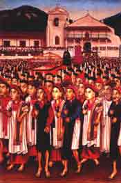
People still remember when every Indian had to donate up to
a third of their labor to the government or some important person, usually
a ladino, in order to get the proper stamps on Even their beautiful clothing has been changed; the
reason that the clothing is striped is that the Spanish imposed the different
colored stripes on the different towns as a way of distinguishing between
them andtherefore as a way of controlling them. To this day certain towns
keep to those
colors that were assigned to them. The beauty of the whole thing is that the
people were able to transform these restrictions into something exquisitely
Mayan by adding their own touches, the fantastic birds, the esoteric symbols,
the beautiful embroidery that takes over the prison stripes and lets the true
nature of the Ah.... that term.... gringo... In Guatemala a gringo is anyone that is not from around here. If you are American you are a gringo...If you are French you are a gringo...on the lake, if you are from Guatemala City or Xela you are also a gringo. It is not meant in its original derogatory sense. It's more of a tag so that people can keep track of you. So relax, gringo...it is also a liberation. Being a gringo, you are excused from a lot of the social restrictions that have been imposed (the locals are pretty conservative). You are, after all, a gringo and just don't understand....besides, everyone knows that gringos are crazy anyway!!! |

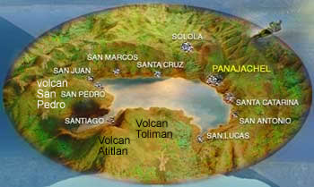
 nature of the Indians; It is all set up as a
visual representation of the world as the Maya knew it . The world is set
up on the axis of the tree of life, which splits up not only physical space,
but also time itself. The different towns were positioned on the special cardinal
points, starting with Santiago and proceeding towards Cerro de Oro and on
around the lake. The circle also follows the old calendar; 18 months of 20
days each and the 5 special "dead days" that fall miraculously on Easter week.
The towns are named because of where their positions are according to the
Saints day that corresponds with the date that fits with where the town is
(!?)Santiago Atitlan, the largest town on the lake, owes its importance to
its position as the center of the Tzutujil nation, and because of the pass
to the coast. At one time, before the Pan American Highway, this was the main
North- South route in the country .The Tzutujil portions of the lake include
Cerro de Oro, Santiago, San Pedro, San Juan, and San Pablo. The rest of the
lake is now inhabited by Cakchiqueles who took over after the conquest.
nature of the Indians; It is all set up as a
visual representation of the world as the Maya knew it . The world is set
up on the axis of the tree of life, which splits up not only physical space,
but also time itself. The different towns were positioned on the special cardinal
points, starting with Santiago and proceeding towards Cerro de Oro and on
around the lake. The circle also follows the old calendar; 18 months of 20
days each and the 5 special "dead days" that fall miraculously on Easter week.
The towns are named because of where their positions are according to the
Saints day that corresponds with the date that fits with where the town is
(!?)Santiago Atitlan, the largest town on the lake, owes its importance to
its position as the center of the Tzutujil nation, and because of the pass
to the coast. At one time, before the Pan American Highway, this was the main
North- South route in the country .The Tzutujil portions of the lake include
Cerro de Oro, Santiago, San Pedro, San Juan, and San Pablo. The rest of the
lake is now inhabited by Cakchiqueles who took over after the conquest.  There
is another pass to the coast at San Lucas Toliman that is now the main pass
to the coast, due to the paved hiway that goes around the lake from Panajachel,
through San Lucas, and down to Cocales, on the southern coastal plain.
There
is another pass to the coast at San Lucas Toliman that is now the main pass
to the coast, due to the paved hiway that goes around the lake from Panajachel,
through San Lucas, and down to Cocales, on the southern coastal plain. his papers. In other words,
the conquest has continued into our lifetimes. The beautiful people that live
here today are not the same as their Mayan ancestors. They retain some of
the old customs, but for the most part the reasons for these customs has been
lost in history. These are a people that have been pretty thoroughly
subjugated for the last 500 years and the tribal memory is very hazy.
his papers. In other words,
the conquest has continued into our lifetimes. The beautiful people that live
here today are not the same as their Mayan ancestors. They retain some of
the old customs, but for the most part the reasons for these customs has been
lost in history. These are a people that have been pretty thoroughly
subjugated for the last 500 years and the tribal memory is very hazy. "natural Indian " shine through. This power is the only hope
for their culture and will hopefully allow them to take in this rush of civilization
that has arrived in the last 10 years, when Guatemala opened it's doors up
wholeheartedly to the new world and took up it's place as one of the consumer
nations. Hopefully, they will be able to embroider their culture onto these
new concepts and emerge from the exchange gracefully, retaining that beauty
and that cultural autonomy that so few of the world's people still have.You may think that I have been exaggerating the case, but,
when I arrived in Guatemala in 1976 you could not even buy a watch or a calculator,
much less a radio or a television. Now there is cable in several of the towns
on the lake, and it isn't all directed at the gringos.
"natural Indian " shine through. This power is the only hope
for their culture and will hopefully allow them to take in this rush of civilization
that has arrived in the last 10 years, when Guatemala opened it's doors up
wholeheartedly to the new world and took up it's place as one of the consumer
nations. Hopefully, they will be able to embroider their culture onto these
new concepts and emerge from the exchange gracefully, retaining that beauty
and that cultural autonomy that so few of the world's people still have.You may think that I have been exaggerating the case, but,
when I arrived in Guatemala in 1976 you could not even buy a watch or a calculator,
much less a radio or a television. Now there is cable in several of the towns
on the lake, and it isn't all directed at the gringos.